
This walk is a circular route that takes in the Hertford Union canal and the Limehouse cut as well as a section of the River Lee navigation.
The walk starts at Three Mills which is at Bromely-by-Bow. At the time of the walk, in 2011, lots of preparations were underway for the Olympics, including refurbishment of part of the towpath. The section northwards from Three Mills was out of bounds, so I had to follow the nearby road as far as the crossing with the A11.
")
Three Mills at Bow
After the A11, parts of the new, raised pathway were visible, but not yet in use, so I had to follow the existing towpath on the north eastern bank.
")
New elevated towpath under construction, north of Bow Bridge (5)
")
Rail bridge (8), with Olympic stadium coming into view
Having dropped down to the canal level, the towpath was clear from obstruction. The canal meanders generally northwards, passing under some road and rail bridges. However, approaching Old Ford Lock, the towpath was closed off by the Olympics so I had to again climb back upwards, to join the Greenway path which I followed as far as Wick Lane. The Greenway crosses over the canal, affording views of Old Ford Lock and the river tributary which meanders in a loop around the Olympic stadium.
")
Old Ford Lock, with the Olympic stadium
I followed Wick Lane northwards until it crossed over the canal at the Wick Lane bridge (6). I could still not find an easy way down to the canal so I continues south eastwards, through a car park and into Victoria Park. A short distance inside the park was a pathway leading down to the Hertford Union Canal near the Parnell Road Bridge (5).
")
Middle lock and the Parnell Road bridge (5)
From here on, the towpath was unobstructed and so I continued along the Hartford Union Canal, using the northern towpath.
")
Hertford Union Canal, beside Victoria Park
The canal is crossed by a selection of old bridges, with the canal narrowing at each bridge.
")
Gunmakers Lane Bridge (4)
On the southern side of the canal are various houses, and modern apartments, whilst the north side of the canal marks the boundary of Victoria Park.
")
Hertford Union Canal, moored boats and overlooking houses
Despite the strong sun (which was causing my camera to occasionally overheat), the canal was often in shade from tall trees both on the towpath and in the nearby park.
")
View from Skew Bridge (3) towards Grove Road Bridge (2)
Many of the houses on the south side of the canal had made a feature of the water, by making small jetties, or terraces by the side of the canal. Several rowing boats and canoes were in evidence. The smell of afternoon BBQs was on the breeze.
")
Bottom of the garden, beside the Hertford Union Canal
")
Pottering about beside the water
Another two bridges could be seen in the distance – first a more modern bridge spanning a gap where the canal narrowed, presumably where an older arched brick bridge once stood.
")
Approaching Grove Road Bridge (2)
Finally the last bridge came into view and prompted a last look back north eastwards along the Hertford Union Canal, before the walk continued on the Regent’s Canal.
")
Looking back from the junction with Regents Canal
The junction of the two canals is a pretty location, with a wide turning point in the Regent’s Canal, and two bridges and a lock in close proximity.
")
At the junction with Regent’s Canal
An enormous willow tree was half-hiding the Old Ford Lock to the north, but the walk continued southwards.
")
Regents Canal and the Old Ford Road Bridge (54)
This section of Regent’s Canal has only four locks as the canal descends to the Thames at Limehouse Basin. The towpath south of the Roman Road bridge had a small length of mooring and was surrounded to the east by parkland.
")
Looking north on Regents Canal, south of the Roman Road Bridge (55)
The canal is quite wide here as it descends towards Mile End Lock, and the feeling of spaciousness is aided by the wide water surface and the relatively low buildings on the western shore.
")
Globe Town, heading towards Mile End Lock
Fairly soon, Mile End Lock comes into view as the canal narrows and is enfolded in brick walls and houses.
")
Mile End Lock
The canal drops eight feet at this lock.
")
Mile End Lock top top gate
Right next to Mile End lock is Mile End Bridge with its low archway over the towpath.
")
Mile End Road Bridge (57)
The canal widens a little after the bridge.
")
Looking back towards Mile End Road Bridge
In the distance, the tall buildings of Canary Wharf are visible as is a lone brick chimney, by the side of the towpath.
")
Heading towards Victory Bridge (59) with Canary Wharf in the distance
Passing under the rail bridge, the penultimate lock comes into view.
")
Salmon Lane Lock
Shortly after Salmon Lane Lock, the final lock at Commercial road can be seen underneath the DLR bridge.
")
Underneath the DLR bridge at Limehouse Basin
As one passes under this final bridge, the Limehouse Basin fills the view.
")
Commercial Road Lock entering Limehouse Basin
From the where the canal enters the Limehouse basin, it is a little awkward to get right south as far as the Thames, so instead, I headed up to road level and crossed to the opposite side of Commercial Road, before dropping back down to the water – this time on the southern towpath of Limehouse Cut.
")
Limehouse Cut
Limehouse Cut is a straight canal stretching from the Limehouse basin, as far as Bow Locks. The only punctuation along its route is a small side mooring about one third the way along, and the various bridges.
")
Mooring a third of the way along Limehouse Cut
The northern bank has no towpath, but the one on the south side is well maintained.
")
Limehouse Cut, near Violet Road Bridge (3)
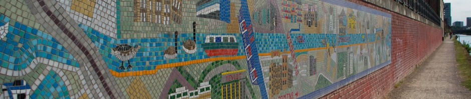
Near Violet Road Bridge, there is a large mural depicting Limehouse Cut, giving distances to the two ends in the form of time taken to walk there. 25 minutes it would take me to get back to Three Mills…
")
Mural along Limehouse Cut
Next along the Cut comes Bow Locks, which link Limehouse Cut and the River Lee.
")
Approaching Bow Locks from the south
Lots of information is displayed here.
")
Map of local waterways
Crossing the bridge over the locks gives a good view in all directions, including the high buildings of Canary Wharf to the south.
")
Bow Locks
Several bridges cross both the canal and the River Lee, which run side by side here.
")
Bridge (1)
As well as the main river, Prescott Channel branches off to the east.
")
Rail Bridge (3A)
Pretty soon, the fantastic buildings at Three Mills come back into view and this circular walk is complete.
")
Back at Three Mills
I did not use the GPS for this walk, but GoogleMaps says that this circular walk is 6.1 miles long.
View Limehouse Cut & Hertford Union Canals in a larger map
Thank you for your post about this canal walk. I am visiting from Australia and completed this walk today. It was a sunny day and the walk very enjoyable. I would not have discovered it if it wasn’t for your site.
Regards,
Suzanne
Thank you for the information you posted about this canal walk. I am visiting from Australia and completed this walk today, following your directions. It was a sunny day and very enjoyable walk. I would not have discovered it if it wasn’t for your post.
Regards,
Suzanne
Glad to hear it went well. One of my favourite walks.